
What is the jet stream?
In the simplest terms- Jet streams are relatively narrow bands of strong winds in the upper levels of the atmosphere.
- The winds blow from west to east in jet streams -- but the flow often shifts to the north and south.
- Jet streams follow the boundaries between hot and cold air OR a stream forms directly over the center of the strongest area of horizontal temperature difference.
- Since these hot and cold air boundaries are most pronounced in winter, jet streams are the strongest for both the northern and southern hemisphere winters.
- Jet streams steer weather systems.
- Jet streams are often the location of frontogenesis or the development of low pressure systems. These ideas are for another lesson.
- Oftentimes television meteorologists indicate a jet stream as a line on a map. This line generally points to locations of the strongest wind.
- How to draw a basic jet stream map: Method 1 and Method 2.

Complexities
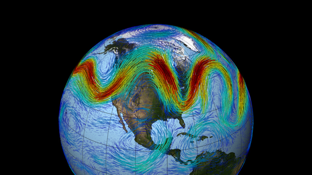
In the reality the jet stream is more complex. In the real atmosphere, jet streams are wider and discontinuous; they are a region where the wind increase toward a core of strongest winds.
One way of visualizing this is to consider a river. The river's current is generally the strongest in the center with decreasing strength as one approaches the river's bank. It can be said that jet streams are "rivers of air". Click on the image below for a loop, courtesy of NASA's Goddard Space Flight Center
The jet stream is driven by broader planetary circulations. The actual appearance of jet streams result from the complex interaction between many variables, including:
Here is a quick look at the idealized model of global circulation patterns that drives the jet stream:
One way of visualizing this is to consider a river. The river's current is generally the strongest in the center with decreasing strength as one approaches the river's bank. It can be said that jet streams are "rivers of air". Click on the image below for a loop, courtesy of NASA's Goddard Space Flight Center
The jet stream is driven by broader planetary circulations. The actual appearance of jet streams result from the complex interaction between many variables, including:
- the location of high and low pressure systems, warm and cold air, and seasonal changes.
Here is a quick look at the idealized model of global circulation patterns that drives the jet stream:
 |
| Image 1 |
 |
| Image 2 |
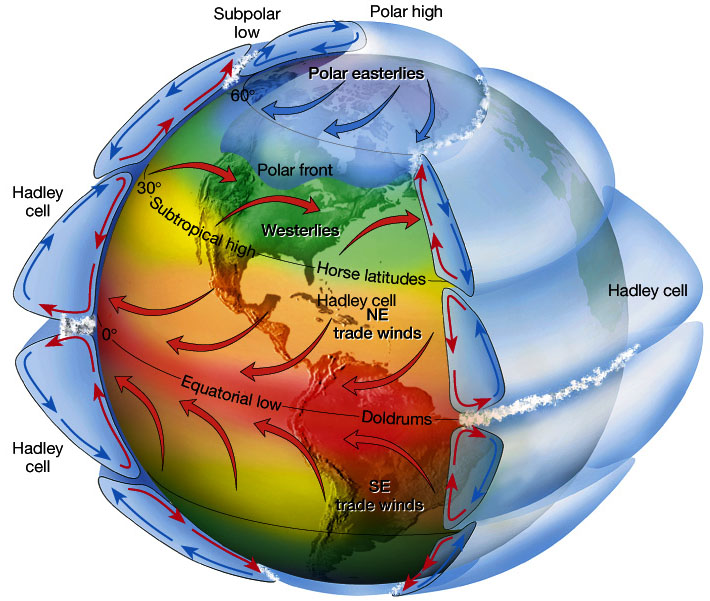
I stated above that the jet stream is driven by broader planetary circulations. In simple terms: these planetary circulations themselves are driven by: (1) the rotation of the earth and (2) differential heating between the equator and the north pole. The image above shows the primary circulations in the northern hemisphere. (Similar circulations occur in the southern hemisphere).
Now the atmosphere as a whole is always in motion. Why? It's our Sun. The Earth is unevenly heated and the uneven heating creates a circulation.
One of my college professor's said something like: everything is looking for equilibrium. The atmosphere is always looking for equilibrium, a state of balance. I supposed it can be likened to to strange game of "whack-a-mole". If one things moves out of place, there is a reaction to put it back in it's place. It's a cause-and-effect relationship (which can be seen as Newton's Third Law of Motion: For every action there is an equal and opposite reaction.) Or in simple math terms: both sides of the equation must balance out.
Here is a brief look at atmospheric circulations as seen in the image above (Image 2), i.e. the Hadley Cell, Polar Cell, and Ferrel Cell:
Hadley Cell - it is a thermally (heat) driven closed-circulation loop, between the Equator and 30 N.
- Strong solar heating at the equator leads to at the rising air; creates an equatorial low pressure zone or better known as the Intertropical Convergence Zone (ITCZ)
- Aloft, air moves poleward but acquires a west to east motion (due to the Earth's circulation).
- Air descends at 20°- 30° latitude to form's subtropical highs.
- Air moves towards the equator at the surface (to replace the rising air) and a weak Coriolis force creates the NE trade winds.
- Creates relatively warm "Sub-polar" Lows
- Created relatively cold "Polar" Highs.
- Air flows from high to low, i.e. the Pole toward 60°, i.e. equator-ward.
- Coriolis forces direct the surface winds to the west, creating polar easterlies.
Ferrel Cell: this is a secondary circulation feature, more dependent on the Hadley and Polar Cells and, to a great deal, is influenced by the high and low pressure areas of the mid-latitudes. It is not a true "closed-loop" circulation. It is marked by an area known as the Prevailing Westerlies.
- Air flows north away from the sub-tropical high toward the subpolar lows (i.e. 30° to 60°).
- In the Western Hemisphere this is the location of United States
- The base of the Ferrel Cell is characterized by the movement of air masses.
- The location of air masses is influences by the location of the jet stream.
- The upper Ferrel cell is not well-defined, partly because it is the intermediary between the Hadley and Polar Cells.
Cause of Jet Stream
So what causes the jet stream to occur?
In general:
On Earth, in the atmospheric circulation model briefly described above, this generally occurs at the intermediary location between the Hadley and Polar Cells. And more specificially there two (2) jet stream locations, the Polar Jet (at the intermediary between the Polar and Ferrel Cells) and the Subtropical Jet (at the intermediary between the Hadley and Ferrel Cells.
Polar Jet Stream:
In general:
- Winds are strongest immediately under the tropopause.
- If two air masses of different temperatures or densities meet, the resulting pressure difference caused by the density difference (which causes wind) is highest within the transition zone.
- The wind does not flow directly from the hot to the cold area, but is deflected by the Coriolis effect and flows along the boundary of the two air masses
All these facts are consequences of the thermal wind
relation. This is beyond the discussion of this lesson, but the balance of forces on an atmospheric parcel (i.e. a conceptual "chunk of air") in the vertical
direction is primarily between the pressure gradient and the force of gravity,
a balance referred to as hydrostatic. In the horizontal, the dominant balance
outside of the tropics is between the Coriolis effect and the pressure
gradient, a balance referred to as geostrophic. Given both hydrostatic and
geostrophic balance, one can derive the thermal wind relation: the vertical
gradient of the horizontal wind is proportional to the horizontal temperature
gradient. This means that temperatures decreasing polewards implies that winds
develop a larger eastward component as one moves upwards. Therefore, the strong
eastward moving jet streams are in part a simple consequence of the fact that
the equator is warmer than the north and south poles
On Earth, in the atmospheric circulation model briefly described above, this generally occurs at the intermediary location between the Hadley and Polar Cells. And more specificially there two (2) jet stream locations, the Polar Jet (at the intermediary between the Polar and Ferrel Cells) and the Subtropical Jet (at the intermediary between the Hadley and Ferrel Cells.
The
thermal wind relation does not explain why the winds are organized in tight
jets, rather than distributed more broadly over the hemisphere.
One factor that
contributes to the sharpness of the polar jet is the undercutting of
sub-tropical air masses by the more dense polar air masses at the polar front.

Look at Image 2 above. In the idealized circulation pattern, the southern side of the Polar Cell (i.e. near 60° ) is "tucked" under top of air of the Ferrel Cell at the same latitude.
- This causes surface low pressure and higher pressure at altitude. This is an area of steep pressure gradient.
- At high altitudes, lack of friction allows air to respond freely to the steep pressure gradient with low pressure at high altitude over the pole.
- The acceleration/deceleration of the air flow induces areas of low/high pressure respectively, which link to the formation of cyclones and anticyclones along the polar front in a relatively narrow region. That is more for another lesson.
The mean or average location of the Polar Jet varies from season to season and is largely due to differences in heating. It is generally weaker and further north in the Summer and stronger and further south in the Winter. Here is an image of the average location of the jet stream in the winter versus the summer over the United States:
Sub-tropical Jet Stream:
This forms similar to the polar jet stream, however this is generally weaker than its poleward cousin because the thermal gradient is less defined.
No comments:
Post a Comment